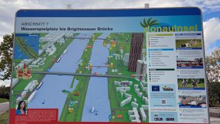
Information boards and floor markings on the Danube Island
A total of 35 information boards are situated at all key points on the Danube Island, from the southern tip right up to the Langenzersdorf inlet barrage at the northern end.
The boards divide the Danube Island into 11 sections, each with a schematic map and overview of the respective section and current position.
The information boards show the location of:
- Sports facilities: boat hire, bike hire, beach volleyball courts etc.
- Restaurants, cafés and bars
- Children's playgrounds
- Car parks
- Police stations
- Public transport stops
- Drinking fountains
- Public toilets
- Nudist areas
- Dog exercise zones and dog bathing areas
- Barbecue facilities and barbecue zones
The information boards provide a brief overview of the LIFE DICCA project, with a QR code link to the website for in-depth information. The boards also list useful telephone numbers, such as the European emergency number and the number of the Inselinfo service centre (German).
Floor markings
All paths on the Danube Island have floor markings at hundred-metre intervals dividing the island into zones. Consisting of the kilometre number and a letter of the alphabet, these floor markings allow the exact position to be pinpointed, which is extremely important for e.g. ambulance crews in case of emergency.
Further information
City of Vienna | Water Management
Any questions, requests, or concerns? Please contact the City Service at contact form


